
The valley of Kazaviti has many places of very early settlement. Like a ribbon, the ancient sites run through the valley. Some are in old maps but are no longer mentioned today. The presence of ores, fertile soil, a lot of water and a geographically favorable location are an ideal settlement base. This article wants to name the individual sites and make them known to the public. An archaeological, scientific background does not exist. Some of the sites mentioned here have been thoroughly destroyed over the years or cleaned of ancient traces.
Byzantine watchtower
Beside the road from Prinos to Kazaviti the foundations of an old watchtower have been preserved (GPS: 40 ° 43’50 “N 24 ° 36’6” E, about 40.730556, 24.601667 on maps). It is a square building in the middle of today’s olive grove. It is said that the origin is Byzantine
Antique traces
Just below the watchtower is the spring Anevras, the uplifting. There are old stories that it is underground connected to the mainland. In the area of the spring are many fragments of ancient buildings. An ancient column, rectangular carved stones and many old potsherds (GPS: 40 ° 43’34.9356 “N 24 ° 36’33.2028” E, position on Google Maps). The spring was unfortunately badly damaged by a bulldozer several years ago. In this area, the old road to Mikro Kazaviti is located.


On the left side of the road to Kazaviti stood the remains of an ancient building. Until the 1980’s, the remains of columns were visible above the street. The place is mentioned on old maps, but today hard to find.
Old way with Christian inscription and ancient wall scraps.
Shortly before the first sharp bend towards Kazaviti, a very old footpath leads along the slope towards Kazaviti. The access is on a private, fenced plot. (GPS 40 ° 43’37 “N 24 ° 36’53” E) On many stones along the way old inscriptions can be found. The most striking is a Christian inscription with a date. At this point, holes were cut in the rock. Presumably the holders for a small roof. Along the way there are many stones with striking geometrical shapes.


Graves from the classical Greek era
Following this path leads to a very exciting area. Above a former goat’s crest are the larger fragments of two sarcophagus (GPS: 40 ° 43’39 “N 24 ° 37’20” E, approximate location on Google Maps). From the classical Greek epoch there are three people buried and named by inscriptions in the stone. At the site of the hotel next to the goat’s crest, the fragment of another sarcophagus became visible. The whole area around the graves is covered with old potsherds and hewn stones. Handmill fragments from very hard, imported volcanic rock, stamp TASOS on the neck of ampfores (about 400 BC), Roman roof tiles (tegula) and rectangular stones. On the relatively steep slope above the graves a fragment of a large marble statue was found. (An old story tells of the head of an ancient statue used as a step by the shepherds of the goat’s crag long ago)


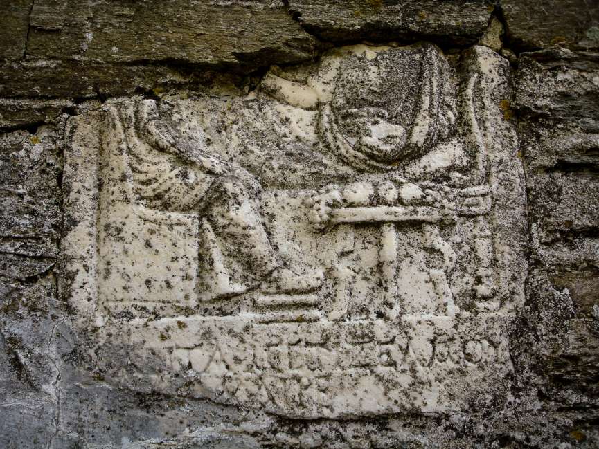
Ancient traces in Kazaviti
In Kazaviti old reliefs were build into the walls of some houses. They were probably found in the vicinity and build in the wall for decorative purposes. Similar examples can be found at a house in Limenas (Thassos). In the former school, in front of the church, there was a relief with a rider. This was stolen a very long time ago. In another wall, the fragment of another relief are preserved. Two men are sitting at a table. The table is richly covered with fruit and grapes. Thassos was famous in antiquity for its good wine. Even today, countless wine press testify to the great wine history of the place. In addition to the reliefs, very heavy, rectangular marble slabs were used for door stocks and floors. Due to their heavy weight and the transportation possibilities at that time, they were most likely found in the area.
At the circular path in the upper part of the village is a previously unexplored grave (GPS: 40 ° 43’32 “N 24 ° 37’27” E, location on Google Maps).
In the ravine above the road at the village entrance there are old irrigation systems (GPS: 40 ° 43’21 “N 24 ° 37’32” E, approximate location on Google Maps). The gorge is very narrow at this point and is good for dam water. The construction and the material used differ greatly from the otherwise encountered architectural style.
Just below the village, on the old road, there is a building of unknown function. For a shelter it is too small. The supported stone slab weighs tons.


More tracks
If you follow the gravel road above the former goat’s crest to a wide firebreak, you will reach the Agdari area (location on Google Maps). There, parts of an ancient water pipe have been preserved for irrigation. A mountain saddle leads to the bare ridge Velanida. This zone is very rich in potsherds and metal ore veins (position on Google Maps). At the highest point is constant cool draft from a cave opening.
The individual places can be combined to an “archaeological walk” from Prinos to Kazaviti.
More detailed information about each location is always welcome. Here you can contact us.
Share this Post
Diese Seite ist auch in: verfügbar